
Page 127 - JOURNAL OF LIBRARY SCIENCE IN CHINA 2018 Vol. 43
P. 127
XIA Cuijuan / The opening and application of Chinese historical geography data in Digital Humanities projects of libraries 127
making data available in a non-proprietary open format (e.g.., CSV). The fourth star is for using
open data standards (e.g., RDF, SPARQL). Finally, the fifth star is for linking your data to other
data or datasets (Berners-Lee, 2009). In order to realize the open application of Chinese historical
geography data in a broader sense, the author suggests that data can be published according to this
scheme.
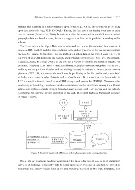
The 5-star scheme for Open Data can be achieved well under the technical frameworks of
ontology, RDF and LD, and it is also conducive to the authority control in the Internet environment
(W. Liu, C.J. Zhang, & Xia, 2015). LD is a method to publish data on the Web. It takes HTTP URI
(interpreted as a URL following the stability and permanence principles of Cool URI (Sauermann,
Cyganiak, Ayers, & Völkel, 2008)) as the URI for a variety of entities and instance objects. For
example, “Anchang Xian” takes <http://data.library.sh.cn/placename/anchangxian/> as its URI,
realizing the unique identification and positioning (access) in web-scale. Once a place name is
given an HTTP URI, it possesses the conditions for publishing to the Web and is easily associated
with the place names in other datasets such as GeoNames. LD requires that data be encoded in
RDF serialization format, stored in local RDF storage, and queried by SPARQL. Moreover, after
combining with ontology, machine-readable associations can be established among the different
entities and instance objects through federated query across local RDF storage and the datasets
(GeoNames for example) already published on the Web. The overall technical framework is shown
in Figure 4 below.
႓㔲 Ꮑ⩕㈨㐌
41"32- &OEQPJOU
3FTUGVM "1*
⩕ᝤᴒ䄏≼㻵 ڲღࡼ䄰
8FC⩹䲏 Ꮑ⩕⼸Ꮌᣒऐ喍"1*喎
41"32-
ᴒ䄏
ࢳटౝ⤳Ԏᖜ㈨㐌喍 NEC喎
㑾㐉⮫喍 DTW喎 ӊᢛ᱙Ҁಸ 3%'ႅוᏀ (FP/BNFT
ౝऺ䓋ڥ喍UYU喎 䒙ᢏ3%'ᵩᐼ 喍(SBQI %BUBCBTF喎
Figure 4. Technical framework of Chinese historical geography data open application.
One of the key goals and needs for constructing this knowledge base is to offer open application
services of historical geography data to other application systems, in addition to providing
humanists and library readers with query and browsing interface on the Web. Therefore, it is